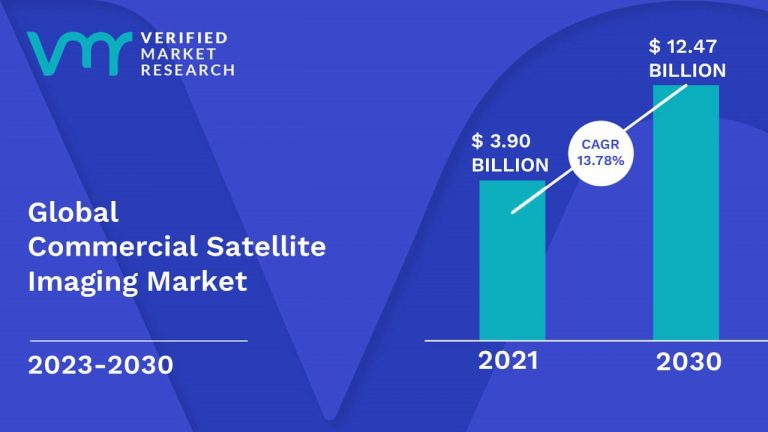
Lewes, Delaware, Dec. 03, 2024 (GLOBE NEWSWIRE) -- Verified Market Research®'s new report projects the Global Commercial Satellite Imaging Market Size to grow at a CAGR of 13.78% from 2023 to 2030. The report reveals that the market was valued at USD 3.90 Billion in 2021 and is expected to reach USD 12.47 Billion by the end of the forecast period.
The commercial satellite imaging market is at the forefront of revolutionizing decision-making across industries. With its wide applications in urban planning, natural resource management, and national security, this market is growing rapidly. Our report provides actionable insights that will enable businesses to capitalize on new opportunities and optimize their strategies in this rapidly evolving field.
Key Insights of the Report Include:
- Strategic insights on emerging trends such as the use of AI and machine learning in satellite data processing.
- Market segmentation analysis, covering End-User, Application, and other key sectors.
- Growth forecasts driven by increasing demand for high-resolution satellite imagery and advancements in imaging technology.
- Competitive analysis identifying key players, strategies, and innovations shaping the future of satellite imaging.
Who Should Read This Report:
- C-level Executives: Looking to expand their footprint in the satellite imaging sector.
- Industry Strategists: Planning for future investments and partnerships.
- Technology Innovators: Developing cutting-edge solutions in satellite imagery and data processing.

Download PDF Brochure: https://www.verifiedmarketresearch.com/download-sample?rid=33819
Browse in-depth TOC on “Global Commercial Satellite Imaging Market Size”
202 - Pages
126 – Tables
37 – Figures
Report Scope
| REPORT ATTRIBUTES | DETAILS |
| STUDY PERIOD | 2018-2030 |
| BASE YEAR | 2021 |
| FORECAST PERIOD | 2023-2030 |
| HISTORICAL PERIOD | 2018-2020 |
| UNIT | Value (USD Billion) |
| KEY COMPANIES PROFILED | DigitalGlobe, Planet Labs, ImageSat International, UrtheCast, European Space Imaging, Spaceknow, Harris Corporation. |
| SEGMENTS COVERED |
|
| CUSTOMIZATION SCOPE | Free report customization (equivalent to up to 4 analyst working days) with purchase. Addition or alteration to country, regional & segment scope |
Global Commercial Satellite Imaging Market Overview
Rising Demand for High-Resolution Imagery in Defense and Security: The defense and security sector is propelling substantial expansion in the Commercial Satellite Imaging Market due to its escalating demand for accurate, real-time data. Satellite imaging facilitates essential decision-making, encompassing surveillance, reconnaissance, and threat assessment. Defense agencies' emphasis on enhanced satellite imagery positions industry participants offering high-resolution solutions for rapid growth.
Emergence of AI and Machine Learning in Data Processing: The amalgamation of AI and machine learning is revolutionizing the Commercial Satellite Imaging Market. These technologies facilitate expedited and precise processing of satellite data, enhancing decision-making in sectors such as agriculture, energy, and urban planning. Companies providing AI-augmented satellite imaging solutions are acquiring a competitive advantage, facilitating new avenues for growth and innovation.
Expansion of Remote Sensing in Agriculture and Environmental Monitoring: The agricultural and environmental monitoring industries are progressively utilizing satellite imaging to enhance crop management, monitor climate change, and oversee natural resources. The increasing dependence on remote sensing technologies is a primary catalyst in the Commercial Satellite Imaging Market. Companies providing customized imaging solutions for these sectors will witness substantial growth as trends in sustainability and precision agriculture intensify.
![]() To Purchase a Comprehensive Report Analysis: https://www.verifiedmarketresearch.com/download-sample?rid=33819
To Purchase a Comprehensive Report Analysis: https://www.verifiedmarketresearch.com/download-sample?rid=33819
High Costs of Satellite Launch and Maintenance: The substantial expense associated with the deployment and upkeep of satellites is a considerable obstacle for newcomers in the Commercial Satellite Imaging Market. This financial obstacle restricts smaller enterprises from competing, resulting in market consolidation among established firms. Consequently, industry leaders must devise innovative, cost-effective solutions to maintain competitiveness while assuring sustainable growth.
Strict Government Regulations and Licensing: The Commercial Satellite Imaging Market encounters rigorous restrictions, particularly for data security and privacy issues. Governments implement stringent regulations on the dissemination and utilization of satellite imagery, restricting its extensive application in specific areas. These regulatory obstacles impede market penetration and hinder enterprises' operational freedom, thereby affecting total growth potential.
Data Accuracy and Integration Challenges: Although satellite imaging provides significant insights, the precision of the data and its amalgamation with other geospatial technologies continue to pose challenges. Inconsistent data quality can impede decision-making for sectors dependent on accurate information, such as energy and urban planning. Companies who neglect to resolve these integration challenges may struggle to sustain market share, hindering the expansion of the Commercial Satellite Imaging Market.
Geographical Dominance
North America dominates the Commercial Satellite Imaging Market, propelled by sophisticated space infrastructure, substantial defense expenditures, and significant demand for satellite data in sectors like as agriculture, defense, and environmental monitoring. This supremacy enhances innovation and competitiveness in the area, promoting the utilization of advanced imaging technology. Consequently, North America's leadership is a pivotal element propelling global market expansion and technical progress.
Key Players
The “Global Commercial Satellite Imaging Market” study report will provide a valuable insight with an emphasis on the global market. The major players in the market are DigitalGlobe, Planet Labs, ImageSat International, UrtheCast, European Space Imaging, Spaceknow, Harris Corporation.
Commercial Satellite Imaging Market Segment Analysis
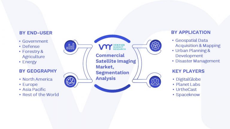
Based on the research, Verified Market Research has segmented the global Commercial Satellite Imaging Market into End-User, Application and Geography.

- Commercial Satellite Imaging Market, by End-User
- Government
- Defense
- Forestry & Agriculture
- Energy
- Civil Engineering & Archaeology
- Commercial Enterprises
- Others
- Commercial Satellite Imaging Market, by Application
- Geospatial Data Acquisition & Mapping
- Urban Planning & Development
- Disaster Management
- Energy & Natural Resource Management
- Surveillance & Security
- Others
- Commercial Satellite Imaging Market, by Geography
- North America
- U.S
- Canada
- Mexico
- Europe
- Germany
- France
- U.K
- Rest of Europe
- Asia Pacific
- China
- Japan
- India
- Rest of Asia Pacific
- ROW
- Middle East & Africa
- Latin America
- North America
Browse Related Reports:
Global IoT in Aerospace and Defense Market Size By Component Type (RFID, Beacons), By Communication Technology (Cellular, Wi-Fi, Satellite Communication), By Application (Real-time Fleet Monitoring, Equipment Maintenance, Inventory Management), By Geography, And Forecast
Global Remote Sensing Services Market Size By Remote Sensing (Satellite-Based Remote Sensing, Aerial Remote Sensing, Ground-Based Remote Sensing), Applications (Agriculture, Environmental Monitoring, Natural Resource Management, Urban Planning and Development, Disaster Management and Response), Industry Vertical (Government and Public Sector, Agriculture and Forestry, Energy and Utilities, Construction and Engineering, Natural Resources and Mining), By Geography, And Forecast
Global High Altitude Long Endurance (Pseudo Satellite) Market Size By Technology (Stratospheric Balloons, Airships, Unmanned Aerial Vehicles (UAVs)), By Application (Military, Surveillance, Communications, Civil), By Geography, And Forecast
Global Telemetry Market Size By Technology (Wireless Telemetry, Wired Telemetry, and Satellite Telemetry), By Component (Telemetry Transmitters, Telemetry Receivers, and Telemetry Sensors), By Application (Healthcare, Automotive and Transportation, Aerospace and Defense, Energy and Utilities, and Retail), By Geography, And Forecast
Top 8 LEO Satellite Companies pioneering future of global connectivity
Visualize Commercial Satellite Imaging Market using Verified Market Intelligence -:
Verified Market Intelligence is our BI Enabled Platform for narrative storytelling in this market. VMI offers in-depth forecasted trends and accurate Insights on over 20,000+ emerging & niche markets, helping you make critical revenue-impacting decisions for a brilliant future.
VMI provides a holistic overview and global competitive landscape with respect to Region, Country, Segment, and Key players of your market. Present your Market Report & findings with an inbuilt presentation feature saving over 70% of your time and resources for Investor, Sales & Marketing, R&D, and Product Development pitches. VMI enables data delivery In Excel and Interactive PDF formats with over 15+ Key Market Indicators for your market.
About Us
Verified Market Research® stands at the forefront as a global leader in Research and Consulting, offering unparalleled analytical research solutions that empower organizations with the insights needed for critical business decisions. Celebrating 10+ years of service, VMR has been instrumental in providing founders and companies with precise, up-to-date research data.
With a team of 500+ Analysts and subject matter experts, VMR leverages internationally recognized research methodologies for data collection and analyses, covering over 15,000 high impact and niche markets. This robust team ensures data integrity and offers insights that are both informative and actionable, tailored to the strategic needs of businesses across various industries.
VMR's domain expertise is recognized across 14 key industries, including Semiconductor & Electronics, Healthcare & Pharmaceuticals, Energy, Technology, Automobiles, Defense, Mining, Manufacturing, Retail, and Agriculture & Food. In-depth market analysis cover over 52 countries, with advanced data collection methods and sophisticated research techniques being utilized. This approach allows for actionable insights to be furnished by seasoned analysts, equipping clients with the essential knowledge necessary for critical revenue decisions across these varied and vital industries.
Verified Market Research® is also a member of ESOMAR, an organization renowned for setting the benchmark in ethical and professional standards in market research. This affiliation highlights VMR's dedication to conducting research with integrity and reliability, ensuring that the insights offered are not only valuable but also ethically sourced and respected worldwide.
